Established during the Civil War on a former Overland Mail route, Fort Bowie (1862-1894) played a key role in the pursuit of Geronimo and his band of renegade Apaches. Free
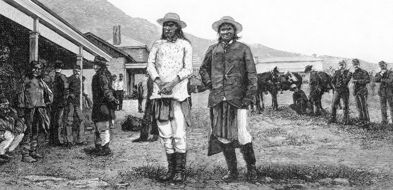
This engraving, made from a photograph, shows Geronimo and Natchez at Fort Bowie after their surrender, September 3, 1886.
Fort Bowie was established in 1862 on a former station of the Overland Mail route. In 1861, the Overland Stage station at Apache Spring had been the site of the famous encounter between George Bascom and Cochise which has become “the most famous incident of the pre-Territorial period, though in wildly distorted versions.”*
The fort played an important role in the U.S. Army’s campaigns against the Chiricahua Apaches. After Geronimo’s surrender in 1886 the fort was no longer needed, and the last troops were withdrawn in 1894. When local citizens removed doorframes and other useful items, the adobe walls began a rapid deterioration, which continued until 1964 when the former fort was declared a National Historic Site and stabilization was undertaken on the ruins. A Visitor Center contains information on the fort’s history and has available for purchase a variety of books on the Indian Wars and life in early Arizona. To reach the Fort take Highway 186 south from Willcox to Apache Pass Road. Follow Apache Pass Road to the parking lot. (There’s also a restroom there which it’s convenient to use before attempting the hike.)
From the parking lot visitors can hike approximately three miles (round trip) to the site of the original fort, passing the remains of the old Butterfield station house and other points of interest. Displays in the Visitor Center highlight the colorful history of the fort. Free
Some of the sites to be seen along the hiking trail include:
Apache Station of the Butterfield Stage
The ruins of the Butterfield Stage Station at Apache Pass are one of the points of interest of the hike to the ruins of the Fort. Prior to the Civil War the Butterfield Overland Stage route ran through southern Arizona, to avoid the heavy winter snows of the Rocky Mountains. Entering present Cochise County at Stein’s Pass, the stages headed west/southwest to San Simon, Apache Pass, Ewell Springs and Dragoon Springs. They crossed the San Pedro near the present town of Benson and then veered slightly north to pass Cienega and head up to Tucson and on to San Francisco via Yuma and Los Angeles. James Tevis, an employee who helped build the station house describes it as follows: “A stone corral was built with portholes in every stall. Inside, on the southwest corner, were built, in L shape, the kitchen and sleeping rooms. At the west end, on the inside of the carral, space about ten feet wide was apportioned for grain room and storeroom, and here were kept the firearms and ammunition.” [Tevis, Arizona in the ’50s, p. 94]
Other stopping points along the hiking trail are the post cemetery, an Apache wickiup, and the foundation ruins of the old Chiricahua Apache Indian Agency once occupied by the controversial Indian agent Tom Jeffords.
The spring at Apache Pass
Anyone traveling across Arizona in the early days, whether by coach, pony or wagon train, soon learned that the trail led from watering place to watering place. Men needed to drink and so did horses and mules. One of the few dependable watering places in this stretch of southeastern Arizona was Apache Spring. It still runs today, and you can pause to rest there as you hike to the ruins of Fort Bowie. It is not recommended to drink the water. Early travelers complained that it was not what they were used to, but most of them drank it anyway.
Site of the Battle of Apache Pass
One of the few Civil War battles Union forces fought in Arizona was not against Confederates but against Apache Indians. The California Volunteers, on their way east in July 1862, had to fight the Indians at a strategic location that became the site of Fort Bowie.
Fort Bowie (1862-1894)
Fort Bowie was established in 1862 and played an important role in the campaigns against the Chiricahua Apaches. After the surrender of Geronimo and his band in 1886, the fort was no longer needed, and it was closed, over the protests of nearby residents, in 1894. A Visitor Center contains information on the fort’s history, and offers a variety of books on the Indian Wars and life in early Arizona.
The map below shows the forts of southeastern Arizona as they were about 1873, before the creation of Fort Huachuca. Fort Bowie can be seen near San Simon in the upper right corner, and Camp Lowell north of Tucson is in the upper left. The map is a zoomed-in view of the 1873 Conley map in the Library of Congress Map Collection. **See the note below on how to find this map and many others on the Library of Congress American Memory website.
In Pursuit of Geronimo
In May 1885, a band of Apaches, led by Geronimo, Nana and Nachez, left the San Carlos reservation and fled to the Sierra Madre Mountains in Mexico. From Fort Bowie and Fort Huachuca, General George Crook pursued the Indians for ten months. At one point, Geronimo agreed to surrender, but, on the night before, changed his mind and again took off across the border, leaving an embarrassed General George Crook to explain the fiasco to his superiors. At this point Crook resigned his command and was replaced by the ambitious General Nelson A. Miles. Geronimo’s final surrender took place at Skeleton Canyon (near Douglas) in September 1886. From there he was escorted to Fort Bowie and later removed to Florida. He lived until 1909, becoming a public figure and national celebrity in his old age.
Fort Bowie National Historic Site is open year round 8:00 am to 5:00 pm daily except Christmas Day.
From Willcox drive southeast for 20 miles on State #186 to the Fort Bowie turn off, then drive another eight miles on the unpaved Apache Pass Road to the Fort Bowie Trailhead and parking lot. There is a walk of three miles round trip to the ruins and back to your car. Handicap access is available if you call in advance and make the necessary arrangements. There is no camping at the site.
From the town of Bowie, the trailhead is located on Apache Pass Road, 13 miles south.
*Altshuler, Constance. Chains of Command: Arizona and the Army, 1856-1875. Tucson: The Arizona Historical Society, 1981.
**To find maps in the Library of Congress collection it is necessary to navigate to the map collection home page and fill in a search word, (Arizona and New Mexico both work) and then select a map from the list generated by your query. Follow the directions to zoom in on the area you’re interested in.